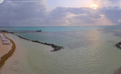

Sorobon Beach
This live stream is brought to you directly from Sorobon Luxury Beach Resort
The Caribbean Netherlands—comprising the special municipalities of Bonaire, Sint Eustatius (Statia) and Saba—offers an extraordinary array of live online cameras that bring the beauty of these islands directly to screens around the world. From the turquoise shallows of Bonaire’s marine sanctuary to the mist‑shrouded slopes of Saba’s Mount Scenery, these webcams provide real‑time views of beaches, harbors, windsurfing bays, and lush hilltops. Whether you’re planning a dive, tracking tropical weather patterns, or simply longing for a virtual island escape, the live feeds dotted across the Caribbean Netherlands serve as your digital window to this remote Dutch territory.
On Bonaire, renowned for its pristine coral reefs and world‑class diving, the Bonaire Marine Park Webcam stands out as a favorite among enthusiasts. Positioned at the Marine Park Visitor Center just north of Kralendijk, this high‑definition feed captures reef‑side activity, from graceful sea turtles grazing on algae to rainbow‑colored parrotfish darting between coral heads. Meanwhile, the Kralendijk Harbor Cam offers sweeping panoramic views of the waterfront—showcasing bobbing yachts, pastel‑hued houses, and the occasional cruise ship docking at the pier. For windsurfers and kite‑boarders, the Lac Bay Windsurf Webcam monitors trade‑wind conditions over the shallow lagoon, giving athletes the insight they need to chase optimal gusts.
Beachgoers and nature‑lovers alike will appreciate Bonaire’s Sorobon Beach Cam, which streams live footage of the island’s famed white‑sand shores. Nestled on the eastern flank of Lac Bay, Sorobon’s cam spotlights sunbathers, beachfront cafes, and a backdrop of waving palms—a perfect place to catch the sunrise or check for incoming rain squalls. Solar‑powered and remotely maintained, this camera even features an integrated weather overlay, displaying water temperature, wind speed and direction, and air temperature in real time. For a glimpse of Bonaire’s historic coastline, the Slave Huts Overlook Cam delivers sweeping vistas of the UNESCO‑protected slave huts and the rugged coastline beyond.
Crossing the channel to Saba, “The Unspoiled Queen” is home to several webcams that reveal its dramatic volcanic landscapes. The Fort Bay Harbour Cam streams continuous footage of the island’s principal harbor, where colorful fishing boats tie up against a backdrop of steep, forested slopes. Aviation enthusiasts can tune into the Juancho E. Yrausquin Airport Cam—famously perched on a narrow shelf between towering cliffs—offering an up‑close look at short‑takeoff and landing maneuvers on what is widely regarded as one of the world’s most challenging airstrips.
For hikers and birdwatchers, Saba’s Ladder Bay Nature Cam provides a window into the lush upland forests along the famed “Road to Nowhere.” With auto‑pan functionality, this camera captures endemic species such as the Saban tremblers and the Caribbean elaenia flitting among bromeliads and tree ferns. Meanwhile, the dormant Mt. Scenery Summit Cam perches at nearly 900 m above sea level, delivering ethereal vistas of cloud‑scudded peaks and, on clear days, glimpses of nearby Sint Maarten and St. Barths on the horizon.
Sint Eustatius, affectionately known as Statia, is no less well‑served by live optics. The downtown Oranjestad Harbour Cam streams dockside activity—fishing vessels unloading their catch, local traders unloading crates of tropical fruit, and the quiet bustle of island life. Complementing this, the Golden Rock Plantation Cam situates viewers amid Statia’s colonial past, framing the ruins of the once‑thriving sugar estate against waving coconut palms and sapphire seas. Each feed offers a unique perspective on the island’s cultural heritage and agricultural landscapes.
Nature enthusiasts can also follow the Quill National Park Volcano Cam, which scans the rim of the Quill crater—an ancient volcanic caldera now blanketed in tropical rainforest. This live feed is equipped with motion detection and infrared capability, alerting park rangers to wildlife movement or unexpected weather changes. Together with the Boven National Park Forest Cam on Statia’s windward ridge, these cameras form a network that helps scientists monitor ecosystem health, track migratory bird patterns, and study the impact of climate variability on Caribbean montane forests.
Beyond mere sightseeing, these live webcams serve practical purposes: hurricane preparedness, marine mammal research, and sustainable tourism. In the hurricane season, local authorities and islanders alike rely on real‑time feeds—especially the coastal cameras on Bonaire and Statia—to track the approach of tropical storms, estimate wave heights, and assess beach erosion. Marine biologists use time‑lapse recordings from the reef‑side cams to quantify coral bleaching events and recovery trends, sharing data with global conservation networks.
Accessing these cameras is straightforward. Most feeds are hosted on the official island tourism websites—Visit Bonaire (www.bonaireisland.com), Tourism Saba (www.sabatourism.com), and Statia’s parks authority portal (www.statiapark.org)—or via popular webcam aggregators such as EarthCam and Windy. Mobile‑friendly streaming apps allow travelers to check conditions on the go, whether they’re en route to a dive boat in Kralendijk or planning a remote hike on Mount Scenery at dawn.
Ultimately, the network of live online cameras scattered across the Caribbean Netherlands represents more than just a digital tour; it is a bridge between island communities and the wider world. By democratizing access to these remote and fragile ecosystems, webcams foster appreciation, support research, and empower local stakeholders to protect their natural and cultural heritage. So the next time you feel the pull of turquoise waters or verdant peaks, simply log on and let the Caribbean Netherlands come to you—live, unfiltered, and endlessly captivating.
The Caribbean Netherlands, comprising Bonaire, Sint Eustatius, and Saba, boasts a rich tapestry of local history that dates back over a millennium. Long before European exploration, the Caquetío people, an Arawak-speaking indigenous group, inhabited these islands, leaving behind shell middens and petroglyphs that intrigue archaeologists and culture enthusiasts alike. The arrival of Spanish explorers in the early 16th century initiated a period of colonial competition, but by 1636 Bonaire and by 1640 Saba and St. Eustatius had come under Dutch control as part of the burgeoning Dutch West India Company empire. As a travel guide expert in local history, you’ll find that many vestiges of Dutch colonial architecture—stone forts, plantation ruins, and windmills—dot the islands, offering immersive insights into the era of sugar plantations, salt trade, and slave labor.
Following the abolition of slavery in 1863, the Caribbean Netherlands began to develop its unique Creole cultures. Papiamentu, a syncretic language blending Portuguese, Spanish, Dutch, African, and Arawakan elements, became the lingua franca on Bonaire, while English and Dutch predominated on Saba and St. Eustatius. Local history tours often highlight the emancipated communities’ resilience, showcasing restored plantation houses turned into cultural centers or museums. These colorful islands celebrate their heritage through vibrant festivals—such as Bonaire’s Dia di Rincon and St. Eustatius’s Carnival—where traditional dances, music, and folklore thrive in the warm tropical breeze.
St. Eustatius earned the nickname “The Golden Rock” in the 18th century due to its thriving free port, which attracted merchants from across Europe and the Americas. Its strategic harbor played a pivotal role during the American Revolutionary War, supplying munitions to the Continental Army. History buffs can explore Fort Orange and the surrounding National Archaeological Parks to trace the footprints of British, French, and Spanish incursions. Today’s island‑hopping itineraries often include guided walking tours of the historic Lower Town, where hidden cisterns, merchants’ warehouses, and cobblestone streets evoke the age of sail and trade winds.
On Saba, local history is written into the dramatic slopes of Mount Scenery, a dormant volcano that dominates the island’s skyline. Originally named “The Unspoiled Queen” by Captain Charles Visscher in 1615, Saba remained largely undeveloped until the 19th century, preserving old‑growth cloud forests and a network of narrow hiking trails. Visitors following our travel guide can discover centuries‑old cottages with coral stone walls and swinging wooden shutters, relics of a bygone era when settlers eked out a living from subsistence agriculture and salt harvesting.
Bonaire’s history is closely intertwined with the salt industry, which flourished under Dutch oversight. Vast salt pans, such as those at the Pekelmeer Flamingo Sanctuary, serve as both ecological attractions and living monuments to the island’s salt trade heritage. Travel guide narratives point out that wind‑powered salt mills once dotted the lagoon shores, their silhouettes now replaced by wind turbines generating renewable energy. As you wander through the salt works, you’ll appreciate how this small Dutch Caribbean island transformed barren flats into one of the world’s most productive salt operations.
The administrative reorganization of 2010 dissolved the Netherlands Antilles and elevated Bonaire, Sint Eustatius, and Saba to “special municipalities” (public bodies) of the Netherlands. Despite their political ties to Europe, these islands maintain distinct Caribbean identities. Tour operators emphasize that visitors still require only a valid passport—no Schengen visa—and can use the U.S. dollar on Bonaire and St. Eustatius or the Caribbean Netherlands public body identifies itself with the Euro on Saba. This blend of Dutch governance and Caribbean charm creates a unique travel experience that appeals to history aficionados, eco‑tourists, and scuba diving enthusiasts alike.
The climate of the Caribbean Netherlands is quintessentially tropical, characterized by warm temperatures year‑round, steady trade winds, and moderate humidity. Average daytime highs hover around 29 °C (84 °F), dipping only slightly to 24 °C (75 °F) at night, making these islands ideal for beach vacations and outdoor adventures. Search engine travelers often look up “Caribbean weather forecast,” “Bonaire climate,” or “Saba weather,” and they’ll find that the dry season from January to April is the peak travel period, boasting clear skies, calm seas, and minimal rainfall—perfect for snorkeling travel guide recommendations and scuba diving expeditions.
From May through November, the Caribbean Netherlands enters its rainy season, with increased chances of brief, intense showers in the afternoons. The islands still enjoy abundant sunshine—often exceeding eight hours per day—but travelers should prepare for occasional cloudbursts by packing light rain gear and checking hurricane trackers. Despite being south of the traditional hurricane belt, the islands remain vigilant from June to November, with Sint Eustatius hosting meteorological stations that provide real‑time wind and barometric data for sailors, pilots, and climate researchers alike.
Trade winds from the east‑northeast blow steadily at 15–20 km/h, tempering the tropical heat and offering welcome relief for hikers on Saba’s volcano trails or divers at Bonaire’s National Marine Park. These breezes also make kitesurfing and windsurfing popular activities in Lac Bay, where shallow waters and consistent wind conditions attract adrenaline seekers. Search queries like “best time to visit Bonaire for windsurfing” or “Saba volcano hike weather” often peak in the spring months, when conditions are most favorable for outdoor sports.
Sea surface temperatures in the Caribbean Netherlands remain invitingly warm, ranging from 25 °C in winter to 29 °C in summer. This consistency makes the region a top scuba diving destination, with dive sites that appeal to both beginners and advanced divers searching for “Caribbean coral reefs,” “shipwrecks dive sites,” or “underwater photography.” Whether exploring easy shore dives on Bonaire or deep wall dives around Saba’s Pinnacles, divers can expect excellent visibility—often exceeding 30 meters—and a kaleidoscope of marine life, coral formations, and underwater caves.
Bonaire, the largest of the three, is a flat coral limestone island fringed by a stunning barrier reef that earned it recognition as part of the Bonaire National Marine Park. The island’s terrain transitions from mangroves and seagrass beds in Lac Bay to saline flats dotted with pink‑hued salt lakes inhabited by flamingos. Inland, the Washington Slagbaai National Park covers nearly 20% of Bonaire’s land area, offering rugged hiking trails, hidden coves, and diverse birdwatching opportunities. Many eco‑tourism searches for “hiking trails Bonaire” or “Birding travel guide” lead explorers to this protected reserve.
Saba, often dubbed “The Unspoiled Queen” of the Caribbean, is a volcanic island of dramatic topography. Mount Scenery, towering at 887 meters, is the highest point in the Dutch Kingdom, cloaked in misty cloud forests that support rare orchids and endemic bird species. A network of well‑marked hiking trails winds through moss‑covered forests and past centuries‑old plantation terraces. Adventure travelers searching for “volcano hikes,” “Saba trail maps,” or “eco‑lodge Saba” will find that the island’s compact size makes it ideal for multi‑day hiking itineraries combined with world‑class diving around the Saba Marine Park.
Sint Eustatius, or “Statia,” features a unique dual landscape: the dormant Quill volcano with its lush crater rainforest on one side, and a rugged volcanic terrain pocked with fumaroles and old lava flows on the other. The island’s coastline harbors extensive coral reefs and underwater pinnacles that attract divers seeking “Statia dive sites,” “soft coral diving,” or “rare species Caribbean.” Above sea level, the Quill trail guides hikers through a pristine tropical forest filled with parrots, hummingbirds, and endemic plant species. Heritage tours often combine visits to the Lower Town archaeological sites with guided snorkel excursions in the protected marine reserves.
Island hopping between Bonaire, Saba, and St. Eustatius offers travelers an unforgettable exploration of Dutch Caribbean diversity. Short inter‑island flights and regional ferry services connect the three public bodies, and search phrases like “Caribbean Netherlands itinerary,” “island hopping Bonaire to Saba,” or “Statia flights” yield comprehensive travel guide resources. Whether you’re chasing the perfect dive site, tracing colonial fortifications, or exploring volcanic peaks, the geography of the Caribbean Netherlands provides an endless playground for adventure, relaxation, and cultural immersion.
Tip: Pack reef-safe sunscreen and a reef‑snorkel gear set if you plan to explore the Bonaire National Marine Park—many dive shops rent equipment, but having your own reef-friendly sunscreen ensures you protect the corals and marine biodiversity during every underwater excursion.
Interesting Fact: Sint Eustatius holds the distinction of being the first foreign port to salute the American flag in 1776, an event commemorated annually on “Statia Day,” marking its pivotal role in the American Revolutionary War and cementing its place in both Dutch and American local history.