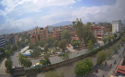

Bagmati River
You can see the Bijuli Bazar Arch Bridge in the upper right
Nepal, a land of soaring Himalayan peaks, rich cultural heritage, and diverse wildlife, has embraced modern technology to bring the beauty of its tourist destinations to viewers around the world. Live webcams strategically placed at key locations allow armchair travelers and eager adventurers alike to experience Nepal’s natural wonders and bustling cities in real time. In this article, we explore the most captivating live cameras across Nepal, highlighting what each camera captures, how to access them, and why they are valuable tools for planning your next Nepalese journey.
1. Mount Everest Region – Capturing the Roof of the World
One of the most iconic live camera feeds in Nepal is situated at the Everest Base Camp region. Perched at Dingboche (4,410 m), the camera offers an unobstructed view of Ama Dablam and, on clear days, the majestic peak of Mount Everest itself. This feed updates every 10 minutes, showing changing weather patterns, climbing expeditions moving across the Khumbu Glacier, and Himalayan sunsets. The live view is invaluable for trekkers planning their ascent, giving real-time information on cloud cover, snowfall, and the state of the surrounding peaks. Accessing this webcam can help climbers adjust itineraries, anticipate difficult weather windows, and even witness Sherpa teams and international climbers as they prepare for summit attempts.
2. Kala Patthar Observatory – Sunrises Over Everest
Complementing the Dingboche camera is another high-altitude feed from Kala Patthar (5,545 m). Although the image resolution is more modest due to harsh conditions, this camera captures glorious pre-dawn light over Everest and the Lhotse-Nuptse massif. During peak trekking seasons (March–May, September–November), viewers can watch hikers and photographers gathering on Kala Patthar’s ridge at dawn. For those unable to trek physically, this webcam provides a daily spectacle of sunrise hues painting the world’s highest peaks, with sherpa settlements and prayer flags fluttering in the cold mountain breeze.
3. Kathmandu Valley – Urban Heritage in Real Time
Nepal’s capital, Kathmandu, is not just a gateway to the Himalaya but a vibrant cultural hub. Multiple live cameras are installed around the Kathmandu Durbar Square, Thamel, and Patan Durbar Square. The Kathmandu Durbar Square camera, positioned near the Taleju Temple, streams 24/7, allowing viewers to observe the ebb and flow of pilgrims, tourists, and local life against a backdrop of centuries-old palaces and temples. During festival days such as Indra Jatra and Dashain, the feed offers a front-row seat to masked dances, chariot processions, and ritual ceremonies. Meanwhile, a live feed from Thamel’s main intersection captures colorful markets, street vendors, and traffic patterns—especially useful for travelers wanting to scope out restaurant queues or peak pedestrian times.
4. Swayambhunath (Monkey Temple) – Spiritual Serenity
Perched atop a hill west of Kathmandu, Swayambhunath Stupa (often called the Monkey Temple) is one of Nepal’s most revered Buddhist pilgrimage sites. A dedicated webcam overlooks the whitewashed stupa adorned with Buddha’s eyes gazing in all four directions. The camera provides panoramic views of Kathmandu Valley shrouded in morning mist or bathed in the golden glow of sunset. Highlights include observing prayer wheels in motion, pilgrims circumambulating the stupa, and the mischievous street monkeys that give the site its nickname. Visitors can tune in at any hour to soak in the spiritual ambiance or plan an early-morning temple visit to avoid crowds.
5. Patan Durbar Square – Craftsmanship and Festivals
Across the Bagmati River lies Lalitpur (Patan), known for its exquisite Newari architecture. The Patan Durbar Square camera focuses on the Krishna Mandir, Vishwanath Temple, and the Royal Palace Complex. Artisans handcrafting intricate wood carvings and metal sculptures can occasionally be spotted when the feed zooms in close during special events. During the Rato Machhindranath Jatra—one of the oldest chariot festivals in Nepal—the live feed captures intricately decorated raths (chariots) being pulled through narrow lanes, as priests and devotees pay homage to the rain god Machhindranath. Patan’s webcam is an essential resource for cultural enthusiasts and photographers scouting for unique festival compositions.
6. Bhaktapur Durbar Square – Living Museum of Newari Heritage
Bhaktapur, sometimes called the open-air museum of the Kathmandu Valley, boasts a perfectly preserved medieval atmosphere. The live camera at Bhaktapur Durbar Square frames the 55-Window Palace, Vatsala Temple, and the iconic Nyatapola Temple. Viewers can watch pottery wheels turning in nearby kilns, artisans molding clay for traditional Newari ceramics, and local residents engaging in daily worship rituals. During the Bisket Jatra festival in mid-April, the feed becomes a portal to the dramatic tug-of-war involving massive wooden poles, traditional dances, and vibrant crowds clad in red and white.
7. Pokhara Lakeside – Tranquil Reflections of Annapurna
Moving westward to the Gandaki Province, Pokhara’s Lakeside area offers a soothing contrast to the bustle of Kathmandu. A prominent webcam installed on one of the beachfront cafes overlooks Phewa Lake, with the snow-capped Annapurna range reflecting off its glassy surface. The feed provides a live display of sunrise over Machapuchare (Fishtail Mountain) and the daily rhythm of boating activities—rowboats, traditional gundas, and paragliders landing near the lakeshore. Travelers can check the camera to gauge weather conditions, cloud cover over Annapurna South, or the serenity of the lake before planning a sunrise boat ride or a paragliding session.
8. Sarangkot Viewpoint – Sunrise and Paragliding Extravaganza
Situated atop a ridge north of Pokhara, Sarangkot offers arguably the best sunrise view in Nepal. A dedicated webcam here captures a 180-degree panorama of the Annapurna Range, Dhaulagiri, and the Pokhara Valley at dawn. Paragliders launching from the ridge are often visible as tiny specks soaring above the valley. This live feed is indispensable for adventure enthusiasts who want to time their tandem paragliding flights for clear skies or to witness the first light illuminating snowfields—moments that often define a Nepal trekking or adventure itinerary.
9. Chitwan National Park – Eye on Wildlife
In the subtropical Terai region, Chitwan National Park’s wildlife cameras provide a window into one of Nepal’s most biodiverse regions. Positioned near the Rapti River and floodplain grasslands, the cameras stream live footage of elephants bathing, rhinoceroses grazing, and a variety of bird species such as kingfishers, herons, and storks. During early mornings and late afternoons, viewers can spot gharials basking on riverbanks, painted storks wading in shallow waters, and elusive Bengal tigers moving stealthily through tall grass. For conservationists, nature enthusiasts, and educators, the Chitwan webcams offer a unique opportunity to study animal behavior in real time without disturbing the fragile ecosystem.
10. Lumbini – Birthplace of Buddha
Lumbini, nestled in the southwestern Terai, is a tranquil pilgrimage site and a UNESCO World Heritage Site. A live camera overlooking the Maya Devi Temple area shows devotees offering prayers, monks in saffron robes circumambulating the sacred pond, and flags fluttering in the gentle breeze. During May (Buddha Jayanti), the feed becomes a focal point for global Buddhist communities who want to participate virtually in candlelight processions, meditation sessions, and cultural performances. The webcam also captures the surrounding monastic zones, where architects from across the world have designed temples—each reflecting distinctive national styles—creating a mosaic of Buddhist architecture.
11. Upper Mustang – Gateway to Forgotten Kingdoms
For those seeking remote vistas, the Upper Mustang webcam perched near the village of Lo Manthang offers a window into the high-altitude desert of the former Kingdom of Lo. The feed updates with desert-like landscapes framed by ochre-red cliffs, ancient fortresses, and colorful prayer flags. While weather conditions can sometimes obscure the view, on clear days one can watch yak caravans traversing high passes, Tibetan Buddhist monks performing rituals, and dust devils swirling across dusty plains. Given the region’s restricted permit requirements, the live camera is a priceless resource for trekkers and photographers gauging seasonal conditions before embarking on the 10+ day Mustang circuit.
12. Annapurna Base Camp – Altitude and Atmosphere
Another notable feed is located at Annapurna Base Camp (4,130 m). While this camera operates intermittently due to extreme weather and connectivity challenges, it offers spectacular glimpses of Annapurna I, Machapuchare, and Annapurna South. During the pre-monsoon and post-monsoon trekking seasons, the webcam streams crisp views of Himalayan ridges, prayer flags fluttering in the cold wind, and occasional sightings of trekking groups ascending or descending the trail. This feed is instrumental for expedition leaders monitoring snow conditions, potential avalanche risks, and base camp logistics.
13. Khaptad National Park – Hidden Western Oasis
In far-western Nepal lies Khaptad National Park, a lesser-known yet ecologically rich region. A modest live camera installed near Khaptad Lake (3,050 m) captures yak herds grazing on alpine meadows, wildflowers blooming in spring, and clear night skies dotted with stars. Though the feed may experience outages during heavy snowfall, when operational, it provides researchers and nature lovers a rare glance at a landscape relatively untouched by mass tourism. The camera’s remote vantage point also highlights local shepherd activity, illustrating the symbiotic relationship between yak herding communities and the fragile alpine environment.
14. Gosaikunda Lake – Sacred Alpine Waters
Gosaikunda, a sacred alpine lake at 4,380 m in Langtang National Park, hosts pilgrims during the annual Janai Purnima festival. A high-altitude camera here captures devotees steeped in icy waters, prayer ceremonies at lakeside shrines, and snow-covered peaks reflecting in crystalline waters. Throughout the year, trekkers on the Langtang Circuit use the live feed to assess snow bridges, trail conditions, and weather patterns—vital for safe passage through Larkya La and other high passes. The camera’s live images of turquoise waters surrounded by jagged peaks provide both spiritual solace and logistical guidance to visitors.
15. Boudhanath Stupa – Buddhist Pilgrimage Icon
In eastern Kathmandu, the Boudhanath Stupa—one of the largest spherical stupas in the world—features a 24/7 live camera perched on a nearby rooftop. Viewers can watch monks circumambulating the stupa, prayer wheels turning, and devotees lighting butter lamps at dusk. During Losar (Tibetan New Year) and Lhabab Duchen (Buddha’s descent from heaven), the feed becomes a vibrant tableau of cultural celebrations, masked dances, and colorful Tibetan prayer flags adorning surrounding rooftops. This camera also provides practical information about crowd density for travelers planning to visit or stay at one of the guesthouses overlooking the stupa’s plaza.
16. Godavari Botanic Garden – Subtropical Flora and Urban Escape
South of Kathmandu, the Godavari Botanic Garden offers a lush respite from city life. A live camera here captures terraced gardens, flower-filled greenhouses, and visitors strolling along shaded pathways. During the annual Flower Show (February), the camera broadcasts displays of rhododendrons, orchids, and roses in full bloom. Botanists and horticulture enthusiasts can identify seasonal flowering patterns, gauge peak bloom times, and explore the garden’s biodiversity— ranging from medicinal plants to rare Himalayan orchids—without leaving home.
17. Tips for Accessing Nepal’s Live Camera Feeds
Most of these live camera feeds are accessible through official websites managed by the Nepal Tourism Board (NTB), regional tourism offices, or private partnerships with telecommunication providers (e.g., Nepal Telecom, Ncell). To find the latest list of active webcams, visit the NTB’s “Live Nepal” portal or check dedicated trekking and travel forums where links are frequently updated. Note that high-altitude cameras may experience downtime during monsoon (July–August) or heavy snowfall (December–February). Opt for lower-altitude feeds in Kathmandu or Pokhara if you need uninterrupted daily coverage.
18. Benefits of Live Cameras for Tourists and Researchers
Live webcams in Nepal serve multiple purposes. Tourists use them to:
19. How to Make the Most of Live Webcams
20. Future Developments – Expanding the Camera Network
As Nepal continues to invest in digital infrastructure, more high-definition, solar-powered, and satellite-linked cameras are expected to come online. Plans include installing 4K live streams at key heritage sites undergoing UNESCO conservation, such as Lumbini’s monastic zones and the Karnali River Basin’s wilderness areas. Additionally, researchers are exploring thermal-vision cameras in wildlife corridors to enhance anti-poaching efforts. These advancements will deepen our understanding of Nepal’s dynamic environments, from subtropical wetlands to the highest peaks on Earth, while promoting sustainable tourism and conservation awareness.
Live cameras at Nepal’s tourist locations offer a window into a country where ancient traditions, natural wonders, and modern technology converge. Whether you seek a virtual journey through Kathmandu’s historic squares, want to gauge the weather on Everest’s flanks, or simply enjoy the serene reflections on Phewa Lake at dawn, these webcams bring Nepal to your screen 24/7. By harnessing real-time views, travelers can plan safer, more rewarding trips, while researchers and conservationists gain invaluable observational data. As Nepal’s webcam network expands, so too will our ability to appreciate and protect the myriad landscapes and cultures that make this Himalayan nation truly extraordinary.
The land that is now Nepal has been a crossroads of ancient civilizations for millennia. Archaeological discoveries show evidence of human habitation dating back to prehistoric times, with stone tools and pottery shards unearthed in various regions pointing to early hunter-gatherer communities. As waves of Indo-Aryan migration spread southward, the Kathmandu Valley became home to complex, rice-cultivating societies that left behind terraced fields and rudimentary irrigation systems. These early inhabitants worshipped nature deities—mountains, rivers, and trees—which laid the foundation for the spiritual syncretism that defines Nepal to this day.
By the first millennium BCE, clans known as janajatis coalesced into principalities ruled by local chieftains. Oral traditions describe the Kirati people—the earliest documented dynasty—governing eastern regions of Nepal around the 7th century BCE. The Kiratis introduced iron tools and expanded trade with Tibet and the Indian plains. Their rule is often romanticized in local folklore, with tales of mountain warriors forging alliances with Buddhist monks who found refuge in remote Himalayan monasteries. Over centuries, the Kiratis were gradually supplanted by the Licchavi dynasty around the 4th century CE, which ushered in an era of urbanization, temple-building, and cultural flourishing.
Under the Licchavis, the Kathmandu Valley saw the construction of its first stone temples, elaborately carved stupas, and royal palaces that became hubs of pilgrimage and scholarly exchange. Sanskrit inscriptions from this period reveal close contact with Indian kingdoms to the south as well as intermittent Tibetan interactions to the north. It was during these centuries that the seeds of Nepal’s famed artistic heritage were sown: bronze sculpture, wood carving, and paubha painting emerged in distinctive local styles, blending Hindu iconography with early Buddhist symbolism. Trade caravans carried aromatic resins, salt, and gold from Tibet, while returning with spices, carpets, and texts that enriched Kathmandu’s libraries.
By the 12th century, the Malla dynasty rose to power, dividing the Kathmandu Valley into three major city-states—Kathmandu, Patan, and Bhaktapur. Each city became a crucible of artistic innovation, building intricately detailed courtyards, towering pagoda roofs, and stone-crafted squares where festivals reverberated with music and color. Devoutly Hindu and Buddhist, the Malla rulers sponsored elaborate festivals like Indra Jatra and Bisket Jatra, which drew pilgrims from across South Asia. City markets thrived, and scholars translated Tibetan texts into Sanskrit and vice versa, creating a unique intellectual class that revered both Shaiva and Vajrayana traditions.
In the mid-18th century, the ambitious leader Prithvi Narayan Shah launched a campaign to unify the warring principalities under a single Gorkha kingdom. His conquest of the Kathmandu Valley in 1768 marked the birth of modern Nepal. Shah’s strategic vision forged a buffer state between rising British interests in India and the Qing dynasty in Tibet. The Shah monarchy established centralized administration, codified laws, and strengthened trade routes through mountain passes. However, limited infrastructure meant that vast tracts of high-altitude terrain remained autonomous or loosely governed by local chieftains for decades.
Throughout the 19th century, Nepal navigated delicate diplomacy with the British East India Company, culminating in the Sugauli Treaty of 1815 after the Anglo-Nepalese War. Though Nepal ceded territory in Sikkim and the Terai region, it retained its sovereign status—an unusual achievement amidst colonial expansion. The Rana autocracy, which rose to power in the mid-1800s, turned Nepal into a hereditary prime ministership, implementing isolationist policies that stifled external influences. Durbar Square palaces and massive stone water spouts (hitis) still stand as reminders of Rana architectural extravagance even as distant villages continued to subsist in relative seclusion.
The 20th century ushered in a gradual opening. Pro-democracy movements in 1950 challenged Rana rule, leading to the restoration of King Tribhuvan and the establishment of a constitutional monarchy. Nepal’s first experiments with parliamentary governance were often turbulent, punctuated by power struggles between the monarch, political parties, and traditional elites. In the 1950s and 1960s, Tibetan refugees crossed the border, establishing settlements that brought Tibetan Buddhism’s scholarly traditions keenly into view. Meanwhile, infrastructure projects—roads, schools, and hospitals—expanded beyond the valley, revealing remote hill towns and mountain hamlets to the outside world for the first time.
By the 1990s, a multiparty democracy coexisted uneasily with a powerful monarchy. Economic hardship and growing disenchantment among marginalized groups gave rise to the Maoist insurgency in 1996. The conflict, which lasted until 2006, devastated rural areas—villages were abandoned, farmland lay fallow, and scores of civilians and combatants lost their lives. Yet the peace process that followed abolished the monarchy in 2008, declaring Nepal a secular federal republic. New provinces were delineated, and former combatants were integrated into national life. Attention turned to reconstruction after the 2015 earthquake, which partially leveled centuries-old temples and highlighted the tension between preserving heritage and embracing modernity.
Today, Nepal still reveres its dynastic past while celebrating its hard-won democracy. Ancient Newar craftsmen continue chiseling wood doors and carving deities, even as young entrepreneurs launch trekking companies and tea houses along Everest Base Camp trails. Pilgrims ascend stone steps to Buddhist monasteries perched on cliffs, while hippies and backpackers drift through lakeside Pokhara, chasing sunrise reflections on Phewa. The tapestry of local history unfolds in red-brick courtyard squares, in the rhythmic peeling of temple bells, and in the whispered legends locals recite to curious travelers who linger too long under starlit Himalayan skies.
Nepal’s climate is as varied as its topography, stretching from subtropical plains in the south to alpine heights in the north. In the Terai region, summer temperatures often soar above 35°C (95°F), accompanied by high humidity. These lowland areas, bordering India, experience scorching pre-monsoon heat from April to June. As summer advances, monsoon clouds roll in around mid-June, drenching the plains with torrential rains that nourish rice paddies and fuel river floods. Humidity remains high until September, when skies begin to clear, revealing emerald fields and forests teeming with life.
In the central hill region, which includes Kathmandu and Pokhara, a more temperate climate prevails. Summers are warm and often humid, but thunderstorms formed by orographic uplift can bring sudden downpours. Monsoon typically begins in late June, persisting until September, replenishing reservoirs and easing wildfire threats. Autumn (October and November) is perhaps the most popular time for visitors: skies are clear, mountain vistas of Annapurna and Langtang emerge crisply, and daytime temperatures hover comfortably between 15°C and 25°C (59°F and 77°F). Winters bring chilly nights, especially at elevations above 1,500 meters, with daytime highs seldom exceeding 15°C (59°F). Frost may dust valley floors by December, and occasional cold spells can drop temperatures near freezing.
Ascending above 2,500 meters (8,200 feet), the climate shifts toward alpine conditions. On trekking routes like the Annapurna Circuit and Everest Base Camp trail, temperatures fluctuate dramatically between day and night. High-altitude passes—Thorang La and Cho La—experience heavy snowfall from December through March, often rendering them impassable. In spring (March and April), chinook winds and warming temperatures melt lower snow layers, exposing rhododendron blossoms and meadows that carpet the hills in vibrant pinks and whites. This season also heralds migratory birds returning to higher elevations, lending an ethereal soundtrack of birdcalls to early morning hikes.
The rain shadow effect of the Himalaya means that northern districts bordering Tibet are the driest in the country. Mustang, Dolpo, and Upper Solukhumbu receive scant monsoon rainfall, resulting in arid valleys where drip irrigation sustains barley fields and apricot orchards. Temperatures in these rain-shadow regions can plunge to -20°C (-4°F) in midwinter, but summers offer clear skies and moderate warmth, making late spring an ideal time for treks through Mustang’s Trans-Himalayan landscape. Travelers to these areas must be prepared for dramatic diurnal temperature swings—sun-exposed ledges burn warm, while shaded gorges dip frigid.
At the highest elevations—above 5,000 meters (16,400 feet)—perpetual snowfields and glaciers dominate. Here, the so-called “death zone” above 8,000 meters presents extreme cold, low oxygen, and unpredictable storms. Mount Everest’s Summit Day in May is characterized by strong westerly jet streams that can exceed 100 mph; only brief weather windows allow climbers to attempt the final ascent. The monsoon typically spares Everest’s northern slopes, but snow can still accumulate fast, endangering base camp operations. Between November and February, mountaineering sticks to lower Himalayan peaks, as Everest expeditions become nearly impossible due to deep snow and sub-zero temperatures.
Nepal occupies a slender stretch of land wedged between two mammoth neighbors—China’s Tibet Autonomous Region to the north and India’s states of Sikkim, West Bengal, Bihar, Uttar Pradesh, and Uttarakhand to the south and west. Although it spans merely 147,516 square kilometers (56,956 square miles), Nepal’s geography is staggering in its vertical range: it rises from the Terai plains at 60 meters (197 feet) above sea level to Mount Everest’s summit at 8,848 meters (29,029 feet). Airlines flying into Kathmandu navigate this dramatic elevation gain on approach, skirting terraced rice paddies that cascade like steps on hillsides.
The Terai belt—a continuation of the northern Gangetic Plain—occupies roughly one-third of Nepal’s land area but houses nearly half its population. Fertile alluvial soil here supports extensive rice, wheat, and sugarcane cultivation. Wildlife reserves like Chitwan National Park, which lies within the Terai, protect Bengal tigers, one-horned rhinoceroses, and gharials in subtropical forests and grasslands. River systems—Koshi, Gandaki, and Karnali—meander through this region, depositing silt that replenishes farmlands but also causes seasonal flooding that challenges rural communities.
Just north of the Terai, the Siwalik Range—also called the Churia Hills—rises in steep, forested ridges. These foothills, composed of sandstone and conglomerate, are geologically young and prone to erosion. Small villages cling to slopes where tea gardens and ginger farms thrive. The Siwaliks serve as a transition zone between subtropical plains and the cooler inner hills. Rivers cutting through these hills create ravines and narrow gorges, often spanned by rickety suspension bridges that sway over roaring waters during monsoon.
Above the Siwaliks, the Middle Hills range from 1,000 to 3,000 meters (3,280 to 9,840 feet). This region includes some of Nepal’s most iconic landscapes: the terraced rice paddies of the Kathmandu Valley, the verdant slopes of Bandipur, and the waterfalls near Sundarijal that attract day-trippers from the capital. The Middle Hills are densely populated with diverse ethnic groups—Newar, Gurung, Magar, Tamang—each maintaining distinct cultural customs, dialects, and farm practices. Stone houses with slate roofs dot hillsides, and narrow bridle paths still connect remote settlements, though winding roads now link many of these hill towns to urban centers.
Beyond the Middle Hills rise the High Mountain region, where elevations range from 3,000 to 5,000 meters (9,840 to 16,400 feet). Here one finds the Annapurna Circuit, Manaslu trails, and the Langtang Valley—each offering trekkers a glimpse of snow-capped peaks, glacial lakes, and yak caravans laden with salt, cheese, and barley. Alpine meadows burst with wildflowers in summer, and stone chortens mark ancient trade routes that once linked Nepal with Tibet. Rivers—fed by glacial melt—carve deep gorges, and high passes like Thorong La (5,416 meters) or Larkya La (5,106 meters) challenge even seasoned hikers with thin air and steep ascents.
Atop the world, Nepal’s Great Himalaya Range houses eight of the fourteen highest peaks on Earth. Mount Everest (Sagarmatha in Nepali, Chomolungma in Tibetan) stands tallest, its summit straddling the border with China. Neighboring peaks like Lhotse, Makalu, and Cho Oyu form a formidable barrier to the north. Glaciers—Khumbu, Ngozumpa, and others—feed the headwaters of major river systems. Glacial lakes, formed by melting ice trapped by moraine dams, glint like sapphires from high plateaus. The arid Trans-Himalayan region of Mustang and Dolpo, sheltered by rain-shadow effects, displays a stark contrast: dusty canyons, eroded cliffs, and ancient Buddhist monasteries carved into sheer rock faces.
Rivers descending from the Himalaya gather speed and volume, carving deep gorges—such as the Kali Gandaki Gorge, one of the deepest in the world—to join tributaries in the Terai plains. These waterways provide hydroelectric power, irrigation, and freshwater fish, though they also pose the risk of devastating floods during heavy monsoon years. The Koshi River, often called the “Sorrow of Bihar,” has breached embankments and reshaped agricultural lands over centuries. In recent times, hydroelectric projects aim to harness the torrents for sustainable energy, though environmentalists caution against disrupting fragile mountain ecosystems.
Nepal’s remote highlands are home to rare and endangered species: snow leopards, Himalayan tahr, and red pandas roam subalpine forests of alpine birch and fir. Conservation areas like Sagarmatha National Park and Annapurna Conservation Area balance tourism with ecological protection. Trekkers trekking through these zones share trails with mules and porters, pausing at tea houses that perch on ledges halfway up mountain spines. The geography of Nepal feels like a living tapestry, each layer—from tropical jungle to frozen summits—woven together by rivers, trade routes, and the enduring spirit of mountain communities.
Tip: When planning a trek through Nepal, consider timing your journey during late September to early November to enjoy clear mountain vistas, vibrant local festivals in the cities, and manageable trekking conditions—avoid the heavy rains of monsoon and the deep snow of winter passes. Interesting Fact: Nepal’s solitary national flag is the only non-rectangular national flag in the world, featuring two stacked pennants that symbolize the Himalaya and the two religions—Hinduism and Buddhism—that have shaped the country’s history.