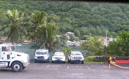

Port of Pago Pago
The view is taken from the southern end of Pago Pago Harbor on Tutuila Island
Nestled in the heart of the South Pacific, the Independent State of Samoa and its neighboring territory, American Samoa, offer a unique tapestry of culture, landscape, and maritime activity that can now be experienced in real time thanks to an expanding network of live camera feeds. These streams transport viewers from bustling urban centers to tranquil beachfront villages, allowing armchair travelers and locals alike to immerse themselves in the daily rhythms of Samoan life. Whether you’re tracking weather patterns, observing harbor comings and goings, or simply soaking in a sunset over the lagoon, these feeds chart a visual odyssey across the archipelago.
In Samoa’s capital city of Apia, a 24/7 live stream provides sweeping views of the waterfront skyline, complete with palm-lined promenades and ferries gliding across the harbor. Hosted by EaseWeather, this high-definition webcam is positioned at latitude −13.833 and longitude −171.767, delivering real-time vistas that capture shifting cloudscapes and the vibrant pulse of urban life citeturn0search0. Complementing this is a suite of traffic cameras from WeatherBug, strategically placed at major intersections and pedestrian crossings to offer up-to-the-minute updates on road conditions in Apia citeturn0search10.
Venturing beyond the capital, the idyllic village of Lalomanu on Upolu’s southern coast boasts its own dedicated webcam, operated by Tiempo3. This feed refreshes continuously, bathing viewers in the azure hues of Samoa’s iconic beaches and providing a window into local beach fale life as waves lap gently at the shore citeturn1search1. For travelers planning their next surf expedition or simply dreaming of white‑sand escapades, the Lalomanu stream functions as both a preview and a distant “Samoan postcard” sent directly to screens worldwide.
Upolu is further dotted with specialized outdoor cams—spots like Savaia, Salelologa, and Vaiala—cataloged by Windfinder, a service focused on swell, wind, and cloud‑cover monitoring. These geographically distributed webcams supply vital data for sailors, surfers, and weather enthusiasts, who rely on the feeds to chart safe courses across fringing reefs and reef‑protected lagoons citeturn0search4. By merging meteorological insight with live visuals, Windfinder’s portal transforms static weather reports into dynamic, panoramic snapshots of Samoa’s ever‑changing skies.
Crossing the international date line to American Samoa, the Port of Pago Pago emerges as the maritime epicenter of Tutuila Island. Operated by Clipper Oil, the harbor webcam broadcasts vessel traffic in real time, capturing everything from tuna seiners and longliners to container ships and luxury yachts as they enter and depart this natural deep‑water harbor citeturn0search19. Viewers can witness the ebb and flow of maritime commerce and leisure, framed by the verdant hills that cradle the port—a testament to the territory’s ongoing seafaring heritage.
For nature lovers and conservationists, the National Park of American Samoa offers a specialized feed at the Ofu Ranger Station. While primarily designed as a weather‑monitoring webcam, this feed allows audiences to observe the interplay of tropical rain showers, dramatic cloud formations, and the park’s lush montane slopes in real time citeturn0search20. By integrating these visuals with park updates and ecological insights, the National Park Service provides a digital window into Samoa’s efforts to preserve its unique biodiversity.
Technologically, these live feeds leverage advances in streaming protocols and resilient coastal infrastructure to maintain uninterrupted coverage—even in Samoa’s remote outer islands. Cameras are often solar‑powered or tethered to backup generators, ensuring that viewers never miss a moment of the sunrise over Manono Island or the busy morning bustle at Apia’s market district. The use of content delivery networks (CDNs) minimizes latency for international viewers, allowing a seamless visual journey from Honolulu to Hamburg.
Culturally, the proliferation of live cameras has strengthened connections between Samoa’s global diaspora and the motherland. Samoans scattered across New Zealand, Australia, and the United States tune in daily to watch family members walk past the village fale or to check surf conditions before boarding a flight back home. These virtual links nurture heritage and communal identity, as viewers exchange screenshots of schoolchildren heading to class or fishermen hauling nets at dawn.
Beyond human activity, many feeds serve as invaluable environmental barometers. Reef‑edge cameras capture coral bleaching events, while coastal webcams chart shoreline erosion after cyclones. Researchers and policymakers integrate these visual records with scientific data to inform conservation strategies and climate‑resilience plans. By democratizing access to these live observations, Samoa’s camera network empowers both experts and laypersons to become engaged stewards of the island ecosystem.
From the animated streets of Apia to the serene expanses of the national park, live camera feeds across Samoa and American Samoa map a compelling visual odyssey—one that blends technology with tradition, commerce with conservation, and local life with global connection. As these streams proliferate and evolve, they continue to break down geographic barriers, inviting everyone to witness the beauty and dynamism of Samoa, one pixel at a time.
The story of Samoa travel and Samoa history begins more than 3,000 years ago with the arrival of the Lapita people, skilled navigators who first settled the Polynesian islands in outrigger canoes. These early voyagers charted vast distances across the South Pacific, bringing with them distinctive pottery styles and community traditions that remain at the heart of Samoa culture today. Archaeological sites on Upolu and Savai‘i islands reveal Lapita village foundations and shell ornaments, linking modern Samoa tourism itineraries to an ancient legacy of exploration and maritime mastery.
Centuries later, chiefdoms emerged under matai leadership, weaving a complex tapestry of oral histories, tattoo arts (tatau), and fale architecture. The Samoan matai system, a cornerstone of local politics, fostered tight-knit villages where ceremonial ceremonies and village councils shaped social life. European contact began in the early 18th century when Dutch explorer Jacob Roggeveen sighted the islands in 1722. Missionaries from the London Missionary Society arrived in 1830, spreading Christianity and reshaping cultural practices—today’s Savai‘i and Upolu churches stand as living monuments to this pivotal cultural transformation.
By the late 19th century, Samoa’s strategic position in the tropical Pacific sparked a rivalry between Germany, Britain, and the United States. The 1899 Treaty of Berlin divided the archipelago: Germany annexed Western Samoa (later the Independent State of Samoa) while the United States claimed Eastern Samoa (now American Samoa). Under German rule, plantation agriculture—particularly copra and cocoa—expanded rapidly, and European-style towns like Apia began to take shape. Traces of colonial-era architecture still dot the waterfront, offering Samoa attractions for history buffs exploring Apia’s historic port area.
World War I saw New Zealand forces occupy Western Samoa in 1914, initiating a mandate that lasted until Samoa became the first modern Polynesian nation to regain independence on January 1, 1962. Under the leadership of the founding father, Mata‘afa Fiame Faumuina Mulinu‘u II, and the apia-based Mau movement, Samoans achieved self-governance through peaceful protest and international advocacy. Today, Samoa travel itineraries often include a visit to the Robert Louis Stevenson Museum, converted from the famous author’s home atop Mount Vaea, where Stevenson spent his final years recording local legends and reflecting on colonial encounters.
Samoa climate is characterized by a tropical rainforest pattern, featuring warm temperatures year-round and high humidity—ideal for lush rainforest hikes and rejuvenating waterfall swims. Average daily highs hover between 26 °C and 29 °C, while nighttime lows rarely dip below 22 °C, making it perfect Samoa weather for island adventures and beach relaxation. Rainfall is abundant, especially during the wet season from November to April, when short, heavy downpours refresh the vegetation and amplify the roar of waterfalls in inland valleys.
The dry season from May to October brings relatively lower rainfall and clearer skies, attracting travelers seeking dependable sun for snorkeling, surfing, and coastal sightseeing. Search trends for “best time to visit Samoa” peak during this period, as Apia sunshine hours soar and wind conditions stabilize for South Pacific sailing excursions. Cyclone risk is also reduced in the dry months, offering safer conditions for open‑water adventures like deep‑sea fishing charters and private boat tours around the coral reefs of Palolo Deep Marine Reserve.
Samoa climate zones vary subtly across islands: Upolu’s eastern shores often receive heavier rainfall due to prevailing trade winds, while Savai‘i’s leeward sides enjoy slightly drier microclimates, perfect for tropical beach resorts and vaka (traditional canoe) excursions. Climate-conscious travelers can monitor live Samoa weather cams on popular beaches such as Lalomanu and Matareva, ensuring they catch the daily sunrise glow or plan around afternoon showers. Whether timing a village festival or a rainforest canopy walk, understanding Samoa weather patterns enhances every aspect of a Samoa travel itinerary.
The geography of Samoa is defined by volcanic origins, dramatic mountain peaks, and encircling coral reefs that cradle jade‑green lagoons. The archipelago comprises two main islands—Upolu (1124 km²) and Savai‘i (1699 km²)—alongside smaller islets like Manono and Apolima. Upolu hosts Apia, the capital city and gateway for international flights, while Savai‘i, often dubbed the “big island,” offers untouched rainforest, lava fields, and the Alofaaga Blowholes, a natural spectacle where seawater erupts through volcanic rock formations.
At the heart of Savai‘i lies Mount Silisili, Samoa’s highest peak at 1858 m, surrounded by O Le Pupu‑Pu‘e National Park, a UNESCO‑listed biodiversity hotspot. Hiking trails navigate through dense tropical rainforest, past endemic bird species like the Samoan flycatcher, to lookout points that afford sweeping views of the South Pacific Ocean. On Upolu, mid‑island highlands give way to tufa caves and cascades—togitogiga waterfalls and Papase‘a Sliding Rocks are must-visit Samoa attractions for nature‑based tourism, combining geology with cultural significance in local legends.
Coastal geography in Samoa underscores the interplay between reef and lagoon ecosystems. Coral gardens flourish along fringing reefs, nurturing kaleidoscopic fish and offering world‑class snorkelling conditions. Visitors often embark on boat tours to Palolo Deep Marine Reserve, a protected underwater canyon just south of Apia, where steep walls plunge to over 70 m and attract pelagic species such as tuna and wahoos. The island’s north coast features expansive beaches with powder‑white sand and crashing surf breaks, a magnet for the global surfing community searching “Samoa surf spots” online to catch the next perfect wave.
Rural villages are integrated into the geography, with taro patches and cocoa farms stretching up volcanic slopes. The traditional land tenure system, tied to matai titles, ensures that ecological management remains community‑driven: conservation of watersheds, reforestation of eroded hillsides, and protection of marine areas are coordinated at the village level. This seamless integration of human geography and environmental stewardship reinforces Samoa’s reputation as a sustainable travel destination and a model for responsible Pacific island tourism.
Transportation across the islands reflects this geographic variety: ferries and day‑cruise vessels connect Upolu and Savai‘i, while domestic flights and charter boats serve the outer islands. Main highways circumnavigate both larger islands, passing through rainforest tunnels, river crossings, and coastal vistas that exemplify “Samoa on a map” for first‑time visitors. Signage in English and Samoan guides travelers to viewpoints like Palolo Peak, where sunrise over the Aleipata Islands conjures those iconic postcard scenes of the South Pacific.
Tip: When planning a Samoa travel itinerary, consider timing your visit during a Tuimanu‘a village fiafia night—a traditional cultural show featuring fiafia dances, siva Samoa, and fiafia feasts under starry skies. These community‑hosted events offer authentic insights into Samoan heritage and provide perfect photo opportunities of dancers in traditional lavea and ie toga costumes.
Interesting Fact: Samoa is one of the few places on Earth where the International Date Line has been shifted twice for economic and cultural reasons—first in 1892 by the Kingdom of Samoa to align with trade partners, and again in 2011 to sync calendars with Australia and New Zealand, making Samoa one of the last places in the world to experience each new day.